'Rides what I like' - Number 1 - 50 hilly miles.
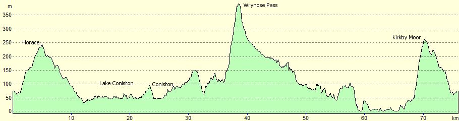
Ascent: 1,694m
A hilly ride on predominantly quiet roads taking in Lowick, Coniston, Little Langdale, Wrynose Pass, Cockley Beck, the Duddon Valley, Foxfield and Kirkby moor.
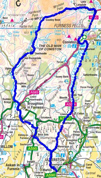
The route
The ride starts at Cross-a-moor about 1.5 miles out from Ulverston on the Barrow-in-Furness Road. Cross-a-moor is just after the village of Swarthmoor. Just after the traffic lights at Swarthmoor turn right (signed Pennington). Pass Pennington school on your left, over the railway bridge, down hill then up past Pennington church on your left, short downhill then first right with the beck and farm on your left. That's the hard navigation over with for a while. All that's left now is to concentrate on the climb up to Pennington Reservoir, which takes you literally through a farmyard. Carry on up the road which eventually levels out with the reservoir on your left. Just after the reservoir, the road dips down, followed by a sharp climb back out to Horace. Carry on up to the first cross-roads, where you turn right. About 100 yards ahead you'll hit another cross roads. Go straight across (signed Lowick). The road continues to climb slightly. You reach the top at a copse of trees on your right. It's worth stopping just past this point before you start a nice long descent. There are great views ahead of Coniston Water and the Old Man of Coniston, and to the right is Morecambe Bay with Hoad Monument (memorial to Sir John Barrow) silhouetted against the sand and sea.
You now start the first of a 3 stage descent to Lowick at the foot of Coniston Water. OK, there's the odd small rise in between, but nothing like you've just done. Take care on the descent, the roads are narrow and twisty with plenty of blind bends. Luckily, there's very little traffic on these roads (you'll be unlucky to see more than a couple of cars on the descent).
The first descent drops you down to the Broughton Beck road. When you hit this, turn right for about 5 yards, followed by a sharp left, then you're off again. This takes you down to the main Lowick-Grizebeck Road. Your way lies straight ahead across the road. In no time at all, you'll be passing Lowick Church on your left, and finally the Red Lion Inn at Lowick, where you hit the main Coniston Road. Cross this road, over a hump-back bridge and immediately turn left (signed Nibthwaite - East of Lake). You're now on the road which will take you along the East Side of Coniston Water. A very pretty road, especially when you hit the foot of the lake. The road hugs the lake shore most of the way, not deviating far from it anywhere. It's a 'rolling' road. No steep climbs but constantly rising and falling. Some great views of the Old Man of Coniston across the lake along the way.
After Brantwood (once home to John Ruskin), the road climbs up and at the top of this short climb, there are great views of Coniston and the Old Man. Well worth a stop here. From here, the road descends back down to the lake. Take care, there's a sharp bend at the foot of the short descent. Again, great views as you cross the head of the lake. You'll now hit the main road. Turn left here and head for Coniston. You have a choice here. Just before you enter Coniston, you go over a hump-back bridge. You can either turn right here (if you don't want to go into Coniston itself), or carry on and take a right at the main road in the centre of Coniston.
You'll soon find yourself on the Ambleside road. This road climbs steadily up to Yew Tree tarn (on your left). A family of swans are usually resident here - I noticed there were 5 cygnets this year (2004) - must be something in the water! Carry on climbing and after a short steeper section, you'll start the descent toward Skelwith Bridge. Don't get too carried away on this descent. You will be turning left fairly soon, signed Wrynose and Little Langdale. Take this left and carry on descending. Make the most of it, this will be some of the last descending you'll be doing for a while. At the foot of the descent, you cross a bridge, and the Wrynose road is waiting for you on the left (complete with forbidding sign!).
From here, it's 4 miles almost exactly to the top of the pass. This isn't what I'd call the start of the pass proper, but there is some climbing to be done before that, and some great views up the valley. Carry on up the hill past Little Langdale Tarn and the Three Shires Inn, a last steep section then a bit more descending and very easy riding up the valley. If you look up ahead, you may be able to make out the odd car winding its way up/down the pass. You'll soon pass over a cattle grid (usually full of water and treacherous in winter) where the road forks. The road up to the right would take you to Blea Tarn, down Wall End and into Great Langdale. We're carrying straight on though, past another sign to remind you of what's up ahead. You'll see a farm in front of you (Fell Foot). There's an interesting Viking mound behind the farm apparently used as some sort of open air parliament in days gone by. Just after the farm, the road does a sharp left and this is where the climbing proper begins. Not much more to say really, other than to ride at your own pace (don't be tempted to keep up with the bloke in front!), ignore any cars behind you - you'll soon reach a passing place where they can squeeze past. Look out as you climb for a large flat topped boulder at the left side of the road, this is called the Pedder stone and was a place where the peddlers of time gone by used to rest as they carried their loads over the Pass. Note that's 'peddlers', not 'pedallers' ;-)
Although it's frowned upon ;-) don't think you have to ride all the way without stopping. You'll miss some great views behind if you do. There's a spot just past a bridge where the road kinks left then right. A wonderful place for a magnificent view back down the valley. I hate to say it, but the really steep bit is just after this. The last 200 metres or so are the toughest. If you weren't out of the saddle before, take care as your front wheel will lift off the ground here if you sit too far back.
Once over the top, keep a look out for the Three Shires Stone on your right. It marks the boundaries of the counties of Lancashire, Cumberland and Westmorland (as they were then). It bears the inscription W.F 1816 on one side and LANCASHIRE on the other. This stone replaced an earlier stone which had all 3 counties marked, which in turn replaced three ancient stones of which now there is sadly no trace.
Just as you start the descent, it's worth stopping and taking a look ahead of you. You'll see the road winding it's way down the valley to Cockley Beck, and, on a clear day, you'll be able to make out that other infamous Lakeland Pass - Hardknott, climbing up the hillside in the far distance.
At Cockley Beck there's a farm house that serves tea/coffee/cake and is worth a stop. It lies at the crossroads of the Wrynose and Hardknott passes and is an idyllic spot when the weather's right and equally impressive when it's not. For those who enjoy solitude, they also rent out rooms. Don't bank on the cafe being open (as I did once after coming over Hardknott!). The opening times seem to be a bit hit and miss, depending on the weather, and what else needs doing around the farm etc. Always worth a knock on the door though, even if it does look closed.
We carry straight on now for Broughton (via the Duddon Valley). This is a lovely part of the ride, taking you through some lovely countryside on narrow twisty roads. You'll pass Birks Bridge then head through Seathwaite, Hall Dunnerdale and on to Ulpha. Over the bridge at Ulpha, the road continues on, with some climbing to Bank End where there's a very steep descent to the main road at Duddon Bridge.
At the main road, turn left and head for High Cross (aptly named - it's at the top of what I always find a leg sapping climb). The main road veers to the right. Carry on on this main road, down a fast descent and head for Foxfield. At Foxfield station you'll pass the first of 2 sets of level crossings. Just past Foxfield station, and just before the road veers round to the left, is the second level crossing. Go over the level crossing - after looking out for trains of course! You're now right down at sea level. Carry on along the shore and take the first sharp left which will take you back over the railway line again (don't forget to close the gates). While there, take a look along the railway line and in the distance you'll see a road winding its way up the hillside. That's your next target.
Once over the railway line, follow this road and wherever you get a chance to take a turn, always go left. Just after you cross a bridge, the road bears left and the surface gradually deteriorates until there's no surface left whatsoever. This only lasts for 200 metres or so. There's a sharp climb up past a farm on your left which then brings you out onto the main road. Turn right here and follow the road to Kirkby. There's a climb up to Kirkby where you need to look out for the Burlington Inn where you turn left. The road meanders up slightly, past a church on your right. It narrows through the village and ahead you can see a steep climb. Luckily just before that starts proper, you take a sharp right (signed Ulverston on the house wall). Now the climbing really starts. Not bad at first, but once you see the sign 'Cattle Grid' you'll be on the climb proper. Its an unrelenting slog up this, but it really is worth it. There are fantastic views to your right of the Duddon Estuary. You'll pass over another cattle grid where the climbing continues (a little easier). Once at the top there's a fast descent then a final climb. At the top of this you turn right (signed Pennington). At the crossroads go straight across (signed Pennington) and you are now on the road you took earlier. Take care on this descent. It's steep in places and narrow.
At the bottom (farm and beck on your right), turn left at the crossroads and carry on on that road back into Pennington and to your start at Cross-A-Moor.