 The
vague idea for this trip came in 2001, when I was on a family
holiday in Austria (based around Zell am See). One day, my
wife and I took a trip over the Großglockner Alpine Road (no, not
by bike unfortunately), and that was me
hooked. I've just got to bring my bike over here, I thought to
myself. I got talking to an Irish bloke on the coach who
obviously had the same idea. I hope he manages it too. The
vague idea for this trip came in 2001, when I was on a family
holiday in Austria (based around Zell am See). One day, my
wife and I took a trip over the Großglockner Alpine Road (no, not
by bike unfortunately), and that was me
hooked. I've just got to bring my bike over here, I thought to
myself. I got talking to an Irish bloke on the coach who
obviously had the same idea. I hope he manages it too.
On the pass that day there were loads of cyclists,
and when the coach stopped for a 'refreshment break', I spent most
of the time wandering around the car park checking the bikes out,
looking at gear ratios etc. Of course the sun was out then!
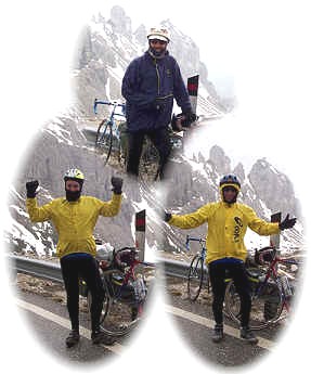
In 2000, Konrad and I had
toured the Marche region of Italy and made a very good friend,
Francesco, from Pesaro. We asked him if he'd like to join us
on this one, and I'm glad to say he agreed. So, it was to be
a truly European affair! Francesco now had a problem.
He needed to 'tourise' his bike. As any self respecting
Italian will tell you, you do not put a rack on a racing bike, and
as for panniers - what are they? The triple chain set also
met with some funny looks apparently, but, after some false
starts, his local bike shop came up trumps and Francesco's lean
mean racing machine was transformed into the cycling equivalent of
the pack horse.
Of course there's lots of
information on the Internet about cycling in the Dolomites and
Alps, but our friend Sergio in Pisa regularly cycles 'up
there' and he was able to pass on lots of useful information on
where to go, where to avoid and also said he would try to meet up
with us and ride for a couple of days. Little did we know
what he was planning!
After some 'umming' and 'aaahhhing', we decided we'd fly to
Treviso (Francesco would get the train from Pesaro), and
then slowly meander
northwards and eastwards over the Dolomites, into Austria, over
the Großglockner and finish in Salzburg where we'd fly
home.
Now Francesco had a cycle
touring magazine which
had a description of a climb called the Lavaredo. He scanned
in the article and climb profile and mailed it to me. The first thing that caught my
eye were the following words 'Difficolta - Estrema'. Even
with my pathetic Italian, I knew what that meant. The profile
alongside those words looked, how can I put this, alarming! It's
basically an 8km cul-de-sac. You ride up, turn round and
ride down. Sounds easy eh! So, as well as the Großglockner, that one was 'pencilled
in' too (until I could find my rubber!)
I'd heard about the 'Sella
Ronda' or 'Sella Ring' which takes in 4 well known passes (well
known to Giro d'Italia fans at least), so that was a must as well.
Anyhow, so this doesn't get
too long, I suppose we set ourselves 3 main targets on this
trip. The Sella Ronda (Sella, Gardena, Campolongo and Pordoi
passes) in one day, the Lavaredo (we hoped without panniers, but
hope doesn't hack it!), and the GroßGlockner (including the climb to the
Pasterze glacier).
It was shortly after deciding
on this basic target, that we came across the 'Climb Profile' site
(see below). Basically this lists most climbs throughout
Europe, and grades them in terms of difficulty. Not just
using a crude metres climbed / distance travelled approach, they
break it down a bit more scientifically, and use those funny greek
symbols that I've never understood. I compared some of these
'difficulty' scores to some climbs in England I know well like
Hardknott Pass (33%), Wrynose Pass (25%) etc, and for some of them, I was a
bit alarmed at the scores they received. Had we bitten off
more than we could chew here?
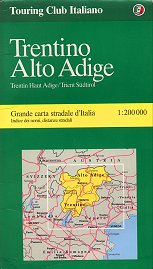 Again, the Touring Club Italiano (TCI) came to our rescue on the map
front with the excellent 1:200,000 map of 'Trentino Alto Adige',
which covered all the Italian section of the route. Again, the Touring Club Italiano (TCI) came to our rescue on the map
front with the excellent 1:200,000 map of 'Trentino Alto Adige',
which covered all the Italian section of the route.
As with previous years, we used Microsoft's
"Autoroute Express - Europe" to get a rough idea
of distances and explore various options. This time we
did find a couple of roads 'missing' in AutoRoute, but Sergio
assured us they were there (we hoped so!)
A major issue with this
trip was avoiding long busy tunnels, and I'm pleased to say we
managed this without any problem whatsoever, thanks in the
main to Sergio and friends offering us good advice. Yes we rode
through a handful of tunnels, but these were short and quiet.
Now May is fairly early to be
riding in the Dolomites and Alps. For example, the GroßGlockner road opens 'early May' depending on the weather,
and accommodation in one or two towns can be a bit thin on the
ground until June.
We booked the first night
in Treviso (always a good idea) as we didn't arrive until
late. We'd heard about a hotel at Kaiser Franz Josefs Hohe
(Pasterze glacier) which sounded amazing, but when Francesco
checked they said they didn't open until June, but recommended
the Hotel Post in Heiligenblut, so, we booked that (and looked
forward to meeting Heidi!). Quite
optimistic to think we'd get there on the right day looking back
on it!
|
|